Sunday, July 19, 2015

Cooper Landing

We said goodbye to Portage Valley and headed south down the peninsula.  Our next destination is Cooper Landing where we would stay at a lodge and RV park on the Upper Kenai River.  Here we were deep into bear and fishing country.  While Cooper Landing is a community, there really is no “downtown”.  The businesses are focused on outdoor adventures of all kinds.  The lodge sits high above the Kenai River.  They have a large patio area that afforded us a restful view of the blue waters of the river and the deep greens of the forest areas.  All around are signs reminding everyone that we were in bear country and to take all the usual precautions about food  and anything else that can attract them.  We were distressed to learn that last year the state conducted two bear hunts as the population had become too large.  Each hunt took 250 Black Bears!  I cannot imagine how they could take that many and still have bear left but apparently they did.  From the park, with binoculars you could see bears on the mountain side eating berries.  As the berries of all kinds ripen, the bears gorge themselves in preparation for the winter sleep.  Every time we went out with the girls to walk into the forest, I felt apprehensive and imagined that at every turn a Black Bear might appear.  Thankfully, that did not happen.

Jim decided to take a fishing trip.  Here on the Upper Kenai, no motorized boats are allowed.  So guides take folks out in boats that drift with the currents.  You can fish from the boat or you can get out and use waders and fly fish.  Here, it is catch and release only; plus, there were no Salmon as of yet.  There were lots of birds that follow the fisherman in hopes of stealing a meal.  There was a Bald Eagle that sat in the same tree each day watching for an opportunity to steal a fish.  As they passed, Jim had a fish on.  The Eagle took flight, screeching as he circled overhead.  This time however, he did not get the Rainbow that Jim had on his line.  Jim had a good day and caught Rainbow, Grayling and Dolly Varden.


The weather was rainy while were there so picture taking was poor.  Here are the only shots we took.

The RV Park sits in a valley at the base of these mountains and above the Upper Kenai River.  This picture was taken at 11 p.m. in the evening.  The sun was fading behind the mountain leaving only the top in view.  Jim went out and took a picture with his cell.  Turned out pretty good.  Even after all this time here, we still are amazed that the sun is still shining near midnight.
One of the Rainbow Jim caught on his fishing adventure.

Portage Valley 3 - The Sun Finally

After spending the morning and early afternoon walking around in showers, the sun finally broke through the clouds and the winds blew away the mist.  The landscape under the sun sparkled and the true colors were bright and deep.  What a difference the blues and greens were under the sun.  We hurried to visit all the different glaciers to see how they looked.  The difference is remarkable.

What a difference the sun made.  The glacial ice glistened blue under the sunlight.
The mountain and glacier was the perfect backdrop for this pretty lake.
These two glaciers a easily seen from the road that goes through the valley.  At the end of the valley is the Anton Anderson Memorial Tunnel.  It is the longest highway tunnel and longest combined highway/railroad tunnel in North America at 13,200 feet.  It uses a computerized system to stage the types of vehicles through the tunnel from trains, 18-wheelers, cars to motorcycles.  When the train is due, the road closes to traffic.  When cars are traveling the tunnel, it is one-way only.  So for fifteen minutes, cars would go to Whittier and the next fifteen cars return.  It is the only way to get to Whittier except by boat.  Originally, the tunnel was only for trains but was expanded to allow vehicles to give land access to Whittier.  Whittier has a port where you can take a ferry to Valdez so the tunnel is an important link allowing land traffic to access the ferry system.  As it is expensive to go through the tunnel so we elected not to go but rather to focus on the valley instead.

A few clouds began to form before the afternoon was over.  Here, Portage Glacier caught the mist as if it were a bowl of snow.
The four of us enjoyed walking through the forest and along the lake shores.  Savannah and Charlotte are like sled dogs pulling Jim along.
Here is a section of the Blue Ice Trail that winds throughout the valley.  It was a lovely way to experience the forest and view the glacier too.
Our final view before we said goodbye and headed out.

Portage Valley 2 - Small Things

We planned to spend this day hiking and enjoying all the sights but Mother Nature decided to send us rain.  Like yesterday when we arrived, the clouds hung low and the air was thick with mist.  We could not even see the glacier just behind where we were parked.  Since we only had this one full day to see the area, we dressed for the weather and headed out.


All the streams here in the forest are very important to Salmon of all kinds.  The Salmon come up the streams to spawn at different times during the summer depending on the type.  There is a Fish Trail that has been developed that allows visitors to see the Salmon in the shallow, clear streams.  Unfortunately, it would be another two weeks before any of the Salmon come into this area.  Well no matter, we could still enjoy walking the trail and who knows what we might see.  As we walked along, the colors and patterns of the plants and flowers began to catch my eye.  I started to really look at these small things that are beautiful in their own right.  I saw how the rain drops glisten on the leaves and flowers.  Now, I am not a real photographer but perhaps you will enjoy my pictures anyway.

At the beginning of the trail, there was an area with placards explaining the life cycle of all the different types of Salmon.  It will be another ten days before the Salmon arrive here in these streams.  I bet that would be something to see.  The trail wound beside this stream and crossed back over it many times.  Overhead, the clouds hung low and the rains came and went.
I began to notice how the moss grew on the bare limbs of trees and bushes that overhung the stream.  It was as if the moss formed a sleeve on the branches.
The ground was covered in many places with lichens.  The texture and coloration was a perfect backdrop for these delicate, green plants.  Simple yet complex in color and texture.
The raindrops formed delicate jewels on the leaves.  If we brushed against them or the wind disturbed them, the water would cascade down the surface and pour into the thirsty ground below.
These tiny, yellow flowers grew beneath the bushes.  Here, the rain had formed tiny droplets on the stalk of this plant.  I wish I knew the names of them.  So tiny, yet very hardy to survive in this environment.
 These tiny berries were all around.  They promise meals for the bears I suppose.
This plant had tiny cones.  Their rust color stood out against the deep greens.
Here is the same plant.  You can see the immature cones with some of the mature ones.  They were everywhere.  I wonder if they can be eaten by the bears?
Fireweed.  This is a common plant seen all over Alaska.  The plant flowers beginning at the bottom and gradually moving upward until the top has blossomed.  The locals say once the top flowers, it means winter is just around the corner.
These tiny white clusters of flowers grew on bushes close to the ground.  There were only a few of them and their stark, white flowers really stood out.
This tiny flower reminded us of Orchids.  Jim had quite a collection of Orchids in Singapore so this little guy amazed us.  Interestingly enough, Orchids grow in all kinds of environments even in the cold North where there is lots of snow.  It looks so delicate but is actually quite hardy.
These tiny berries grew close the the ground beneath the protection of the trees and bushes.  They look like tiny strawberries or raspberries.  I asked what kind of berries they were and was told they were Salmon Berries.  Hmmm, not sure I buy that one.
Scattered here and there were these plants.  They look as if their leaves have already begun to change colors signaling that fall is not far away.  But then again, perhaps this is how they grow.
These leaves really caught my eye.  The perfect, tiny rain drop nestled in the center of the clusters looked like jewels.  Even when the wind blew, the droplets did not fall but stayed firm in place.  Amazing.
When I was a child, my Father would take me fishing on lazy summer days.  We often would see turtles lined up on logs sunning themselves.  The moss on this log evoked images of such turtles.  You can see the reflection of other bushes in the still water.
Another variety of berry glowing among the bushes.  
As the trail ended, we found ourselves standing before a lovely lake.  It was so still that the water reflected the trees perfectly.  A peaceful end to a lovely hike.

Portage Valley, Chugach National Forest 1

Turnagain Arm (I know, a strange name) and Cook Inlet are the bodies of water that border Anchorage.  We drove along these on our way south from Anchorage heading to Portage Valley.  There is so much to see there, birds of all kinds, beluga whales and other sea mammals and just the beauty of the area.  The land rises up to high cliffs where Dall Sheep can be seen, if you are lucky; we were not.  I was in awe all the way.  South of Anchorage lies the Chugach National Forest and Portage Valley.  We headed to the forest where we would spend two days.  This area is perhaps the most beautiful to date.  The forest itself is lush and every shade of green possible.  It is spotted with creeks, fishing streams and Portage Lake.  It is also home to many glaciers.  It seemed as if everywhere we looked, the beautiful blue ice flowed down the face of a mountain.   Our RV site sat at the base of one of these.  We spent two days in wonder at the power of Mother Nature.  Take a look.

The highway out of Anchorage winds south.  On the right is the Turnagain Arm and on the left are shear rock faces.  Some of the locals come out and climb these but mostly only Dall Sheep climb these rocky faces.  There are many places to stop and look at the surroundings.  Beluga Point is a favorite spot.  You can see the whales from there if you are lucky, again, we were not.  All sorts of birds fly overhead.  We saw Bald Eagles and all sorts of water fowl.  So much to see.
As we drove into the Portage Valley, this is one of the sights that greeted us.  This is actually two glaciers flowing side-by-side.  The day was overcast and showers came and went, but even under those conditions the blue of the glacier ice was a wonder to behold.  Over thousands of years, these glaciers have retreated and flowed carving out the valleys and mountains as they moved.  They melt and the water forms lovely, blue lakes and creeks.  The runoff into the rivers turn them milky with the "glacier dust".
This is the entrance to our camp ground.  It sits at the base of a mountain with a glacier.  The camp itself was pretty spartan but the views made up for any lacking.  We walked a great deal  with the girls.  Savannah especially loves to explore and let her nose lead her around.  Several small ponds dotted the area.  The second evening, we saw a Moose cow and her calf walking near on of them.  No, did not get a picture except in my mind's eye.
Here we are standing on the shores of one of the lakes.  The air was very cool and damp.  It seems so odd to be wearing jackets and fleece vests in July!
A great deal of the area is bog-like.  It reminds me of the low country in the South.  It is a great area for birds.  Perhaps we will get a canoe so we can go out and enjoy being on the water and get a closer look at the birds.
This is Portage Glacier the name sake for the valley.  We could get pretty close to the face of the flow but not close enough to get a picture.  The mist hung over the ice swirling in the breeze.
No, this is not a live bear.  This is a Grizzly Bear typical of the area.  We were in the visitor center and this was on display.  I thought it was interesting as you can really see the blond color of the fur on most of the body and the darker brown on the legs and around the face.  As a Grizzly goes, this guy was pretty small.  In any, I certainly would not want to meet him on the trail.  We are instructed not to run but to stand our ground and make yourself look big.  If they attack, roll into a ball and play dead.  Yea, right!

Hatcher Pass

After Talkeetna, we headed to Palmer and Big Bear RV Park.  Palmer and Wasilla sit very close together nestled in the Chugach mountains.  From our site, we could see the snow covered peaks in the distance.  Unfortunately, the light was never good enough for a picture but it was a great view.  We wanted to get out into the area and see the mountains so we headed for Hatcher Pass.  On our way to the pass, we passed through a recreation area bordered by the Susitna River in an area of Castle Mountain Fault.  Not surprising, this area has been active geologically and still is today.  We enjoyed the drive up and into the Chugach range and finally arrived at the pass.  Here are some pictures of the trip.


We left Talkeetna and headed to the pass on Palmer-Fishhook Road.  Funny name for a road but Fishhook is a common road name in combination with other townships names like Willow-Fishhook.  As we entered the recreation area, we stopped to read the information signs and view a river that was flowing next to the road.  Such a peaceful, lovely place.
The water in the river was swift, clear and cold.  The color is blue as the water comes from melting glaciers.  Further along, we saw fly fishermen standing in the water casting for trout. Would be very fun but the water is very cold.
Past the river, we turned on to the road that leads up to the pass.  The views from the roadway were amazing (as usual).  There were so many different shades of green and of course, in the distance peaks rise, many with snow spots on them.
We stopped at an overlook and got another traveler to take our picture.  Yes, we really are together!
The paved road climbed upward toward the pass and a lake, Wonder Lake.  At the end of the paved section, this overlook gives a view of the surrounding mountains.  It is also the trailhead for a couple of hikes -- both go pretty much straight up, not for us!  The colors are just unbelievable.
We were surprised to see folks parasailing.  They would jump from a cliff and the ride the air currents and circle down into the valley below for a landing.  Their colorful sails were quite a sight against the blue of the sky and the fluffy clouds.  Boy, would I love to do that!
After the lookout, the pavement ended and gravel took over.  The road turned and went up steep enough that we used our four-wheel drive.  It circled upward and came to Wonder Lake.  The lake was quite small and the blue reflected back the blue of the sky.  Unfortunately, my picture did not come out but it was beautiful.
Once we went through the pass, we had a choice of continuing on to see where the gravel road would lead us or backtrack and go back the way we came.  Well, we never like to backtrack; besides, we never know what lies over the hill and around the next bend.  As it turns out, we came to an abandoned gold mine.  Above us, some of the remaining equipment sat as witness to the search for gold so many pursued.
For over an hour, we followed the gravel road.  It took us through some of the most beautiful forest ever.  There were picnickers stopped by the roadway enjoying the views and the cool mountain air.  There were many ATV groups camping next the the creeks.  There were even lone tent campers perched on the cliffs below us enjoying nature.  We stopped many times to enjoy the views and to walk into the forest.  Finally, we emerged back at the highway near Willow.  


Willow is one of the villages that has been hit very hard by the fires.  All around the blackened remains of trees stand stripped of their beauty.  Many cabins have been destroyed and the musher's dog kennels burned.  But, out of the ashes the village already is rising once again.  Neighbors have come together to rebuild.  Donations of materials and time are generously given.  The clock is ticking for those who have lost their homes.  Winter is just around the corner and they must get a simple cabin built if they are to survive.  The Alaskan Spirit is hard at work helping all those who have lost their homes.  One man told us that last year his home was burned and the neighbors across the creek helped him rebuild.  This year, their home has burned and he is helping them.  The true meaning of being a good neighbor.

Sunday, July 12, 2015

Talkeetna

We arrived in Talkeetna in rain showers.  Since the weather has been dry and hundreds of fires are burning, it is good for firefighters and home owners but not so much for our trip.  Setting up in the rain can be a challenge but with all the experience we have doing it, piece of soggy cake.  Talkeetna is a great place for all sorts of outdoor activities.  With water all around, fishing, rafting and boating is a big draw for tourists.  It is also a jumping off place for climbers hoping to conquer McKinley.  We were surprised to learn that it takes 18-22 days to gain the summit, wow!

I have to say that so far, this was the only stop that was disappointing for us.  Now don’t laugh but it is too touristy.  I know, I know we are tourists but it just felt like a big tourist trap.  We braved the rain and went to the village to walk about and have a bite to eat.  It was wall to wall.  In addition, we had dinner at a brew pub that Jim wanted to try.  Not only was the beer disappointing, but the food was as well, AND it was expensive.  Well, tomorrow will be a better day.

Or not.  We woke to heavy rain that continued more or less all day and into the night.  The visit was not a total bust.  We visited a local business that makes Birch Syrup.  Yep, I said Birch.  It is made using the same method as maple syrup.  You tap the trees, collect the sap and boil it down to make syrup.  Unlike maple, birch takes about four times the sap to make a gallon of syrup.  I was skeptical but it is quite good.  It is not as sweet as the maple, but it is good.  It is used in a number of products: jams, candy and all kinds of baked goods.  One of the local distilleries that makes craft vodka even makes a birch vodka.  I like a good vodka and tonic from time to time so we bought a bottle.  Oh man, is it ever good?  You bet!  It is only sold in Alaska and expensive so I won’t be taking any home.

We also visited an interesting local bakery called the Flying Squirrel.  They cook organic, locally grown fruits and vegetables and wonderful pastries.  I had a bowl of soup that was probably among the best ever.  We spent an hour or so eating and watching the locals come in and out.  Alaskans are individualists in every way.  I mean that in a good way because I admire them.  They dress and do what they like on their own terms.  It is a pleasure to have a conversation with someone who seem so easy in their own skin.

While we did not fully appreciate Talkeetna, we came away having enjoyed the spirit of Alaska and the people who love her.


Thursday, July 2, 2015

ATV Tour Near Denali Park

After flying in the morning, we struck out for an afternoon adventure.  Years ago, we took an ATV tour in Canada at Banff.  It was great fun as I remembered, so we decided we would take one in the Denali area.  Don’t get me wrong, it was fun but for me, a bit disappointing.  We traveled through the forest and of course, the trees blocked all hopes of seeing anything.  Besides, I was holding on with a death grip!  Jim however was like a kid again.  He loved gunning the engine and plowing through the mud puddles and mud rivers and we bumped and rocked along the trails.  We took a side by side and Jim drove.  We stopped three times to look at the views but they were just ho, hum -- oh dear, have I become jaded?  The weather was threatening rain as we drove along and finally at the last stop, the sky opened and the rain came.  It was cold and windy with lightening and thunder.  Suddenly, the rain turned to hail.  There we stood in the open as the hail pelleted us.  From inside the helmet, it sounded like balls thumping us on the head but on our bodies, well some of it hurt.  We all laughed and hurried back to our vehicles.  Since we were in a side by side, we had a roof and windshield so that protected us to some degree.  While we did not see any wildlife or great views, it was still a fun ride.  I have not seen Jim’s “child” in a long time -- so it was well worth the trip.


We returned to the RV after a full day of flying and driving tired but very glad we had come to this beautiful place.  Vast, powerful and beautiful, the Denali area is not to be missed.

Jim, my driver for the adventure.  He was so much fun to watch as he roared through the mud hole and over the rocks and gullies.  It was worth the trip just to see him laugh with such abandon.
Off we go, single file into the forest.
We are going through that!?!  Indeed we did and much, much more.
 Our chariot for the afternoon.  It was really quite a machine.  Fortunately, it had no problem with the terrain.
Our final stop on the tour was at this formation.  I could not tell you where we were at this point.  I was too busy hanging on for dear life to ask!

Then the rains and the hail started.  Now I love a good time, but standing in hail is not what I consider a good time.  Besides, the lightning bolts were enough to make me wish for a roof over my head.
Okay, it is pretty well maybe not pretty but pretty amazing.

It had been a long day.  Is it Miller Time yet?

Wednesday, July 1, 2015

Denali Park, a Bird’s Eye View

We were told by a fellow traveler that the best thing they did bar none was to take a flight to Mt. McKinley.  From the park entrance, it is actually some 80 miles to the mountain (or the “hill” as some of the locals call it).  If you are very lucky and the weather is clear and sunny, you might get to see the mountain from a few vantage points.  We also knew that the only way we could possibly appreciate the enormity of the park would be to fly over it.  So, we agreed a flight tour was absolutely in order.

After signing all the documents absolving the company of any responsibility should we fall out of the sky or crash land or, God forbid get killed, we boarded a van and headed for the airport.  As an aside, two days later a tour plane did fall out of the sky and nine people died including the pilot.  But of course, we never considered it could really happen, could it?

Before we could board, we had to put on glacier boots.  They were actually designed to wear over our shoes.  Basically, they are soles with waterproof fabric attached that covered our shoes and secured with velcro.  Ingenious!  There were two planes to fly this tour.  Each of them held nine passengers including the pilot.  Lucky Jim, he ended up on the co-pilot seat.  He had a grin so wide on his face it was funny.  I ended up in a seat just behind him with no window, ugh!  How was I to take pictures I wondered.  As it turned out, I got to sit in the co-pilot seat on the return leg and was able to get better pictures.  The conditions were not the best as the weather was iffy.  There were clouds that threatened rain but worst of all, smoke from the fires continued to plague the area.  I asked Eric, our pilot about the smoke and he said we would most likely get above it by the time we reached the hill.


We took off and began to make our way toward the mountains.  Between shooting over Jim’s shoulder through his window and the smoke, taking pictures was a problem.  As we passed over the lower mountains of the Alaska Range, the clouds hugged them and I feared we would not see McKinley after all.  We climbed to 10,000 feet and by the time we got to McKinley, we were at 12,400 feet.  There before us, the top of the north face of the mountain rose out of the clouds giving us a breathtaking view.  What a glorious sight to see, it truly took my breath away.  After flying around the north side, we few to Ruth glacier and landed!  It was exhilarating!  This was truly the trip of a lifetime and I will never forget it.

Here we are ready to soar above the mountains in hopes of getting to see Mt. McKinley.  You can see the glacier boots on Jim's feet.  They are really quite neat and easy to don.  This was not our aircraft but the other plane that went up.  All aboard!
During the first leg of the flight, the smoke in the air made seeing things quite difficult.  I was really worried that we would be disappointed in the trip.  Finally, we began to climb above the smoke.  You can see the clouds and then the mountains come into view.  Took my breathe away.  The mountains are granite and the white snow against the black rock made for quite a view.
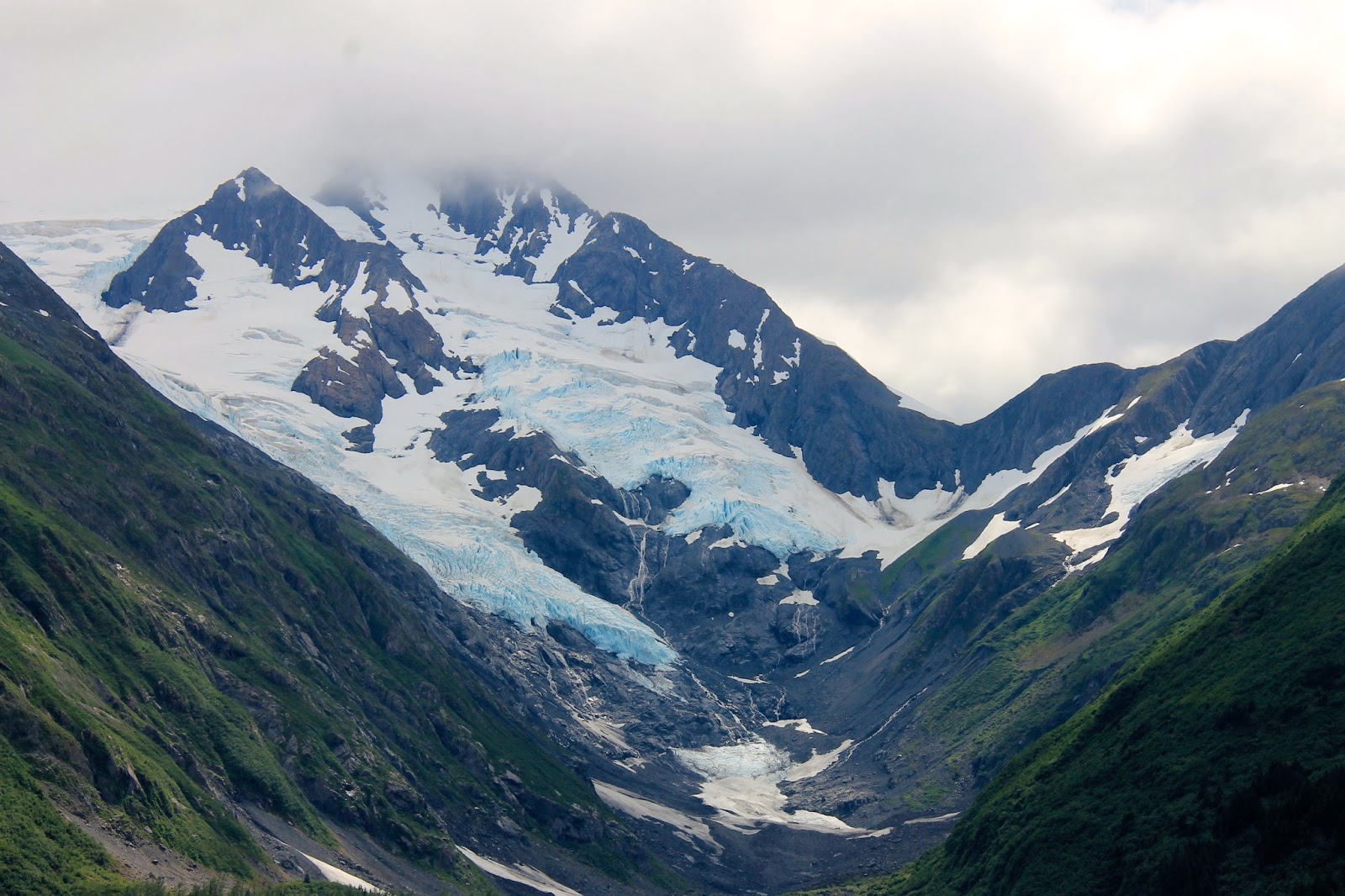
Here is our first view of one of many, many glaciers here in the mountains.  These glaciers are hundreds of feet thick and the power of the ice is amazing.  They carve out huge chunks of rock as they travel down the mountain side.
Another glacier flowing over the side of this mountain. The ice has a beautiful blue color.  It is shame to think that we may one day not have them any longer.
The tops of some of the peaks slice through the air like knife blades.  The air cleared as we rose above 10,000 climbing higher still so we could view McKinley -- 20,320 feet tall.
At first, the clouds seemed to be playing peek-a-boo with us.  We could see the outline of the top of Mt. McKinley but not clearly.  We were approaching the north side of the mountain.
As we flew, the clouds seemed to part and there it was shining in the sun.  The majesty of the sight is something I cannot describe.  It sparkles with power and might such as I have never seen before.  While the clouds clung to the sides keeping us from seeing it from base to top, it did not matter.  Suddenly, I could understand why some people are driven to want to climb peaks such as this.  It must be like a sirens call for sure.
As we flew around it, the vastness of its size is evident in the changes to the shape.  Next to McKinley is a smaller mountain the Indians refer to as its wife.  I think it is so funny how we name all the rocks and mountains as if they were human.  Sometimes I wonder what folks must be smoking when they see the shapes and animals in what they see!
Below and ahead of us lay Ruth Glacier where we would land.  Oh my gosh, I could not believe we were actually going to land there.  What a thrill!
Here we are with Eric, our pilot on Ruth Glacier. We were not the only planes here either.  Eric told us that there are about five different glaciers that they use depending on weather or the whim of the pilots.  Of course, they have all sorts of names for the different ones but from the air, they pretty much look the same to me.  We are at about 9,000 feet on this one.
What would you think this structure could possibly be here on top of a mountain?  Believe it our not, it is an outhouse!  Yep, a bush pilot came up here and build a cabin with an outhouse up here before this area became part of Denali.  Since he and his family had used it for a number of years, they were allowed to keep it.  Can you imagine coming up here for a stay?  Bet it would be a cold shock to the system to have to use this thing!  Burrrrrr!  The cabin itself is tuck over the ridge, we could see the very top but not clearly.  Only in Alaska.

On the return trip, the light was much better.  In the distance, you can see McKinley rising above the other peaks.
This peak just looked surreal to me.  I love the play of light against the darkness of the rock.
As you can see, as we descended the smoke quickly made visibility dropped to nearly nothing.  Below us, the park road winds into the heart of Denali.  I will never forget this day.  Today we truly soared on the wings of the wind.