Saturday, August 12, 2023

On to Glenwood Springs

Another day on the move, this time to Glenwood Springs, CO.  The drive would take only about two and a half hours but little did we know what a beautiful, amazing drive it would be.  Some of the pictures look “fake” but I can assure you, I took them as we drove along in the car.  So much color and grandeur.  We are now settled in the KOA with a lovely view of the mountains.  We will spend three nights here before heading on to Denver where we will meet up with our friends and travel up to their ranch for a couple weeks of peace and amazing vistas.


These are just a few picture of street signs.  We find it odd they way the streets are named.  Often they are in alphabetical order with the first street M 0 followed by M 1/4 the M ½ — you get the idea.  We found it funny.


Black Canyon of the Gunnison

We have been in Olathe, CO for three days now.  The first two days were spent doing errands and making some repairs that happened when driving over rough roads.  Thankfully, Jim was able to fix everything so it all looks like nothing happened at all.  Olathe is a very small town about 10 miles from Montrose, the gateway to the Black Canyon of the Gunnison.  Our drive from Vernal to Olathe was to say the least, nail bitting!  We traveled over highway CO 139 which while it is RV safe, it is less than comfortable.  First, it was rough and undulating.  The speed limit was posted as 65 miles per hour but Jim could only go about 50 without it feeling like our RV was coming apart at the seam!  About a third of the way along, a sign alerted us that the road was narrowing and there would be a steep grade.  Boy, truer words were never written! The road was indeed very narrow and there were no guard rails.  Lots and lots of switchbacks and S curves that would make anyone hold their breath.  It went what felt like straight up.  At one point, I just put my head in my lap and closed my eyes and prayed we would make it.  Now, we drive a RAM 3500, diesel and it is a good thing too cause that thing will pull a house, which it did since our RV is our house on the trip.  Once we cleared the pass and started back down the other side, it was a bit less scary but it is not a road I would care to travel ever again!  We left 139 behind and finished our trip on US 50, a much easier road to manage.  It was not long until we arrived at Olathe.  We are staying at a campground that is for 50+ folks which is quite nice.  Not only is it a quiet campground, everyone we have met is quite friendly and helpful too.


Today we loaded up and headed for Black Canyon of the Gunnison National Monument.  There was a sign at the park that really spoke to me.  “Something will have gone out of us as a people if we ever let the remaining wilderness be destroyed.…  We simply need that wild country available to us, even if we never do more than drive to its edge and look in. For it can be a means of reassuring ourselves of our sanity as creatures, a part of the geography of hope."  I think these words are very true. We live in a beautiful country where all the national parks belong to US.  Each time I visit one of them, I feel richer for the experience and thankful that I live in the USA.


We drove through farm lands that leads to the canyon.  Fields of corn and pastures with beautiful horses and cattle.  Such an amazing place.  The road began to climb upward and we knew that we were entering the monument area.  A bit of history for your reading pleasure.  Explorer and engineer John Gunnison, seeking a Pacific railroad passage in the 1850s, judged Black Canyon impenetrable.  He was referring to the difficulty of getting from one side of the canyon to the other.  What he could not have known was that the river had worn down the canyon walls from a dome of extremely resistant crystalline rock.  A geological event now known as the Gunnison Uplift had raised the canyon’s rock from deep in Earth’s basement.  Two million years ago, the river’s course was determined by the location of high mountain ranges.  The river began cutting through the uplift’s core as it forced rocks, gravel and sediment along scraping the walls and chipping it away. Floodwaters gave the river increased power and it gained speed making a steep descent from the surrounding mountains.  Time was the Gunnison River’s unseen but equal partner.  Together, they carved through time and rock to form what we now call the Black Canyon of the Gunnison.


Unlike the Grand Canyon, the Black Canyon is steep, deep and narrow.  The rim of the canyon drops 2,250 feet down shear granite walls to the river below.  At the bottom, it is a mere 40 feet wide at one point while at the top, the widest point is only 1,100 feet wide.  It is said that some places at the bottom of the canyon get as little as a few minutes of sunlight daily.  What an amazing place.


We spent time at the Visitor’s Center and then headed out to drive the rim road.  The canyon is a great place to be outdoors. There are lots of places to hike, to kayak or canoe and even to rock climb.  But make no mistake, it is not a place for the faint of heart.  Anyone attempting to climb or spend time on the water must be an expert.  The river is treacherous with class III and IV rapids and a climber must be very experienced and have the latest equipment before they can even obtain a permit to climb.  Beautiful but deadly.  Here are some pictures that will take you through the beauty and the beast.


We passed farms that were growing hay.  I cannot imaging how wonderful it would be to wake each day with the mountains in the distance.
While I would find it lonely to live here, I can still appreciate the wonders of nature all around.
Before we arrived at the Visitor’s Center, this overlook gave us our first look at the canyon.  Far below, the Gunnison River looks quite benign.  The black granite that gives the canyon it name, rises rugged and foreboding.  BTW, the Gunnison River is the only river in this area that is a free flowing river.  By that I mean, it has never been dammed or had it course changed by human intervention.
We met two young men at the overlook who were taking pictures using a drone.  It was a treat to watch him launch the drone and them bring it in for a landing.  He showed us some of the pictures it had taken deep in the canyon, wow is the only word that came to mind.
In this area, climbing these rugged walls would be impossible I think or at least, it would not be anything I would dream of doing even if I could climb.


Farther along the rim road, the perspective looking down in the canyon chances at every turn.
We hoped we would see a mountain goat or something but the foreboding granite was more rugged than even a goat could handle.
It is no wonder there is no bridge over the canyon.  It would be an engineering wonder for sure.  Not even one of the daredevils who do all the crazy things would tackle one of these.

These beasts are where climbers try their skill.  The faint of heart they are not! Given it is over 2,000 feet down, I hope they have all the safety equipment they need to complete the climb and go home safe and sound.


We did see some animals.  Here a Golden Eagle was sailing on the updrafts.  These eagles are both beautiful and deadly too.  I would not want to be on their dinner menu.
This little Ground Squirrel was totally at ease with our presence.  Whatever he was eating, he was not about to leave it even if fleeing might be the better choice.
At the last stop, the grandeur was the perfect picture.

Time to head back.  We left applauding Mother Nature for her work in creating this wonder.


Wednesday, August 9, 2023

Dinosaur National Monument

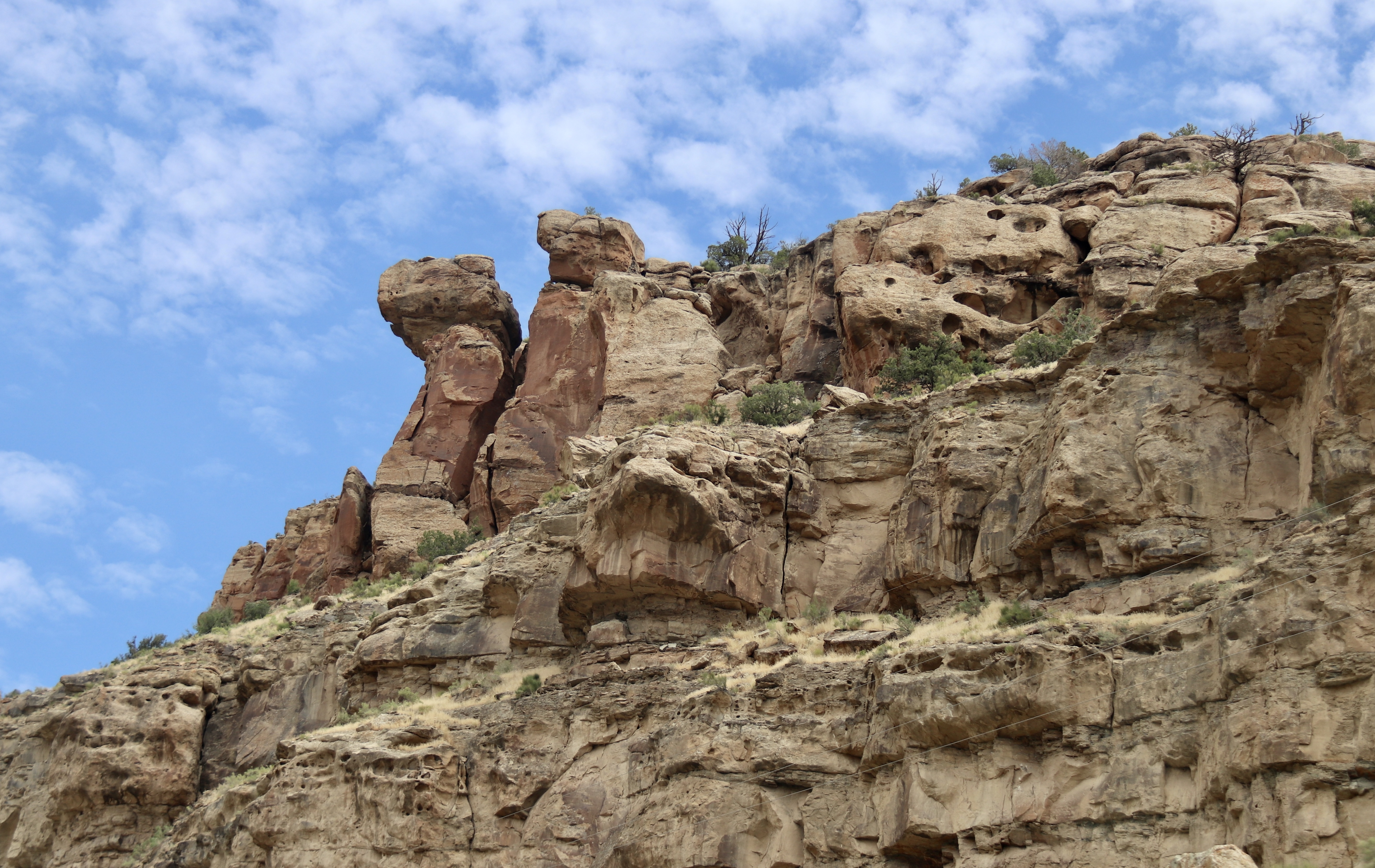
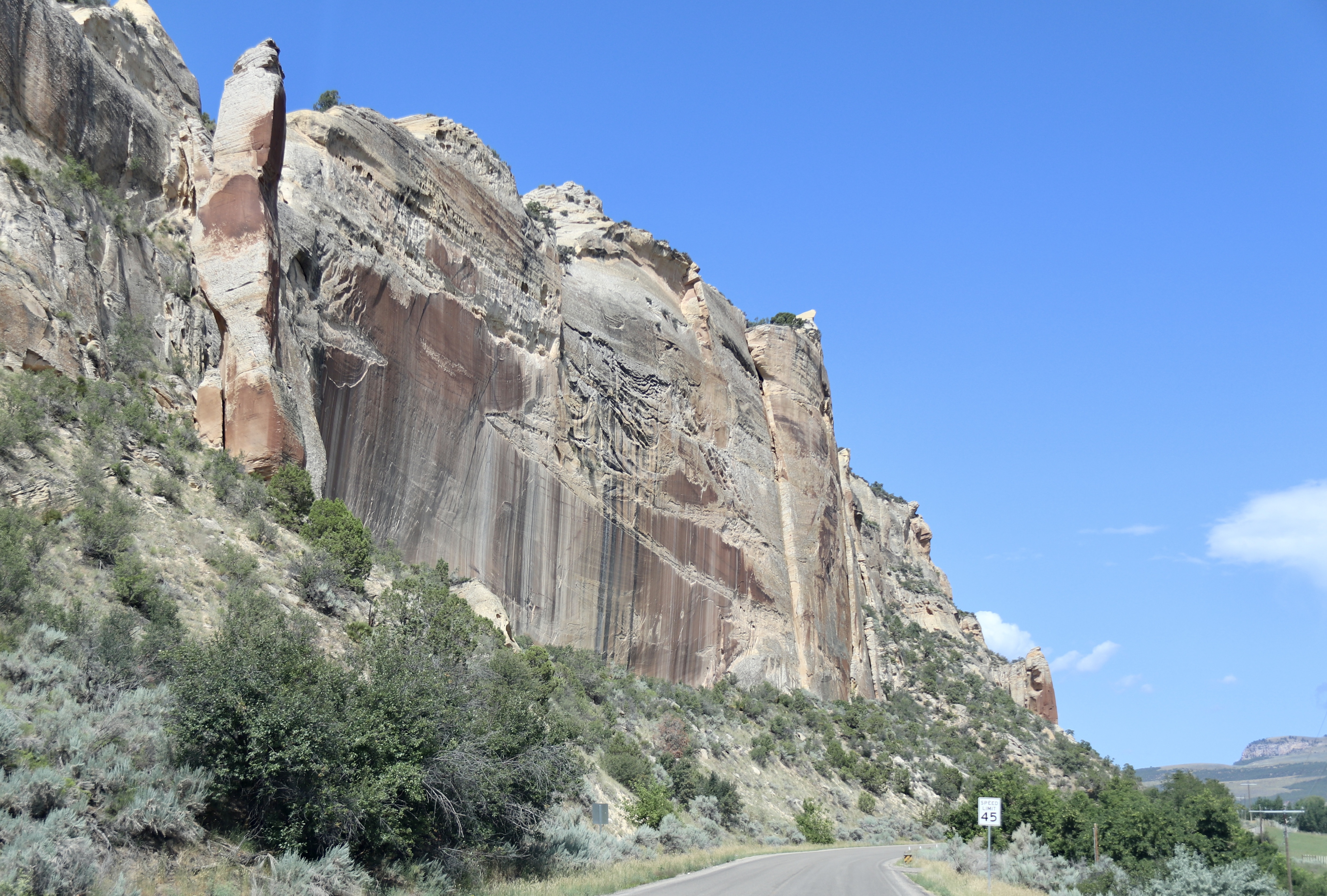
We headed out late morning, eager to get to the monument before the heat of the day.  The drive to the site took us through horse and cattle country.  As we got close, we could see the cliffs and rock formations that held a treasure trove of Jurassic-period fossils.  In 1909, paleontologist Earl Douglass, from Pittsburgh’s Carnegie Museum, found eight vertebrae of a dinosaur called Apatisayrus in the arid badlands of eastern Utah. He had stumbled upon one of the world’s greatest collections of dinosaur fossils.  As we drove through the ever changing landscape, placards described the type of rock formations we were seeing, the timeframe it represented and the animals that would have lived there.  How amazing to know that millions of year ago, all this area was a sea. How do they know?  The fossils of sharks and other aquatic animals have been found in the rocks.


There was so much we saw and learned it is hard to known what to tell you.  I thought we would be walking among the rocks and seeing where the fossils had been found.  But no.  Because of the likelihood of damage to delicate fossils by visitors, the only way we could see them was to visit what they call the Quarry Exhibit Hall.  It is important to note that the hall was built around the rock excavation area.  Once the scientists finished their study and cataloging all the specimens, the hall was constructed.


But first, a bit of background.  Over the years, paleontologist have found fossilized bones of various species.  They more or less make educated guesses about what the animals actually looked like.  Think about a gig saw puzzle.  Without all the pieces or a picture of the completed puzzle, it would be pretty impossible to complete it.  That is pretty much what it is like trying to determine what an animal looks like without all the bones.  Very often, animals die near water.  As water washes over their bones or animals scavenge the bones, they are articulated (pulled apart) and washed downstream.  The result is a mass of bones jumbled together in a mess.  Sometimes, they find sections such as vertebrae or ribs that are still intact.  Rarely do they find a skull with all bones and teeth in tact.  Thus, what they think they know may change 20, 30 or more years later when new findings tell them more about the animal than known before.  At the Quarry Exhibit Hall, a large wall of fossils in situ are on display for the public observation.  This approach was not only to protect the fossils but also to allow the public to see them up close.  Here are some pictures so you can see them.


This is just a small section of the Quarry face.  It is divided into sections.  Each bone is cataloged and studied.  Identification of the fossil bones takes years of collaboration between paleontologists at the Dinosaur National Monument and other museums and universities.
Here you can see a section of vertebrae that has remained intact.  There are over 1,500 bones exposed on the Quarry face.  Many of the bones have yet to be identified.
This bone was in an area where we could touch the actual fossil bones.
A section of ribs for a smaller animal.


This fossilized skeleton of young Camarasaurus (kuh-MARE-uh-SAWR-us) is the most complete long-necked dinosaur ever found. Long-necked dinosaurs are known as sauropods.  With this discovery in 1919, scientists were able to reconstruct a sauropod skeleton based on a single specimen for the first time. Before, ideas about sauropods were based on

incomplete skeletons


Allosaurus (AL-uh-SAWR-us) was the dominant predator of the Jurassic Period.   This is skull of one of the most complete meat-eating dinosaur skeletons ever found in Late Jurassic rocks.


This fellow is another example of skulls found.  This is a cast of the actual skull which is 149 million years old. Hard to even think about something that old.


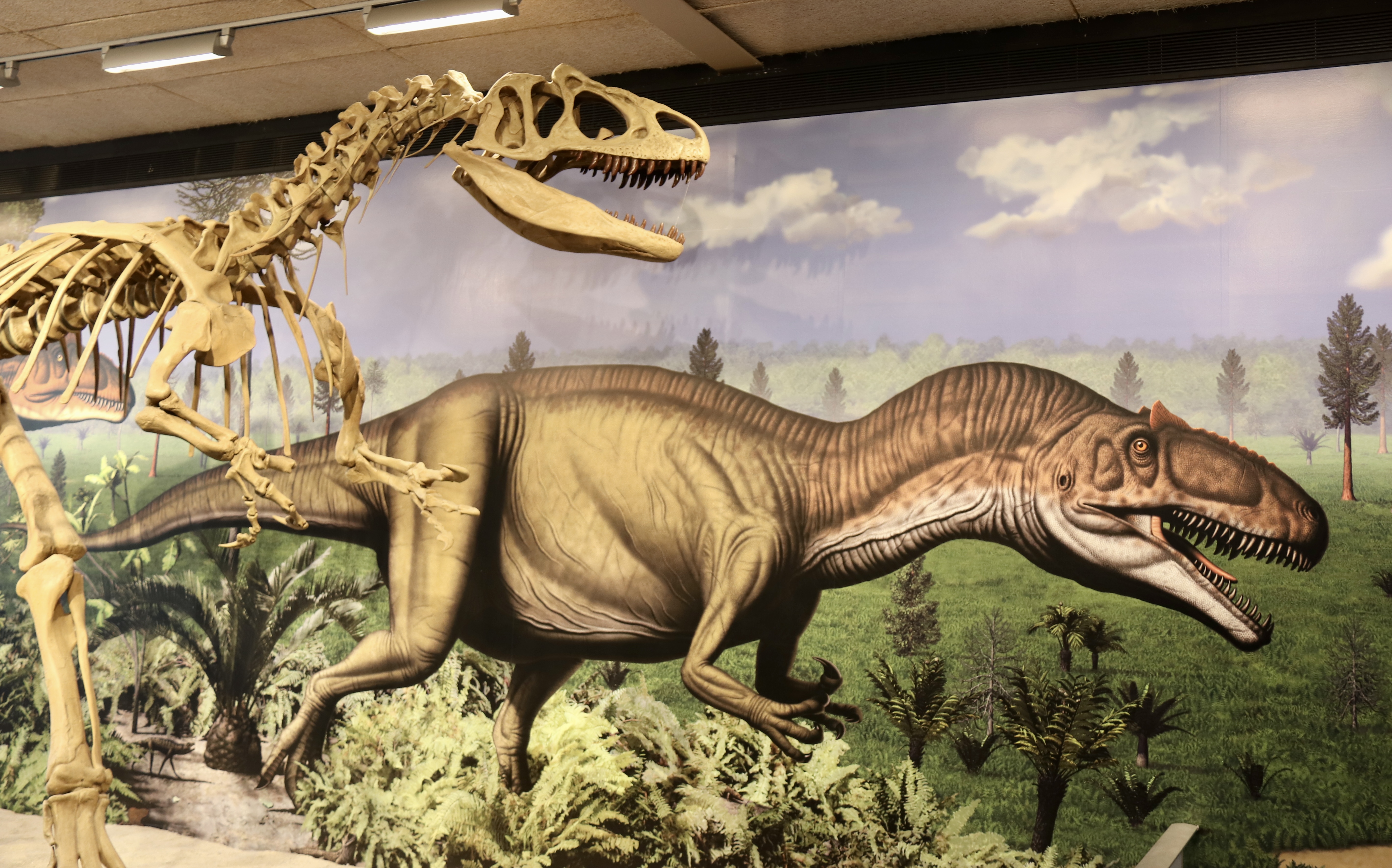
This dinosaur was the most common predatory animal in the Morrison ecosystem.  Allosaurus was well adapted to its predatory role. Sharp serrated teeth lined its powerful jaws. Large curved claws and powerful arm and leg muscles allowed it to kill and eat smaller dinosaurs. Allosaurus probably also ate carcasses of animals that were already dead.  This is a cast skeleton of an Allosaurus from the Cleveland-Lloyd Quarry in east-central Utah.  It is about the same size as the individual from this quarry whose large skull is on exhibit here.


The picture behind the skeleton is what they think the Allosaurus looked like.


After visiting the Quarry, we decided to drive a short distance to see some petroglyphs.  Yea, I will finally get to see some.  Here are some pictures.


Time and the elements have taken a toll on these petroglyphs but they were still amazing to see.  No one really knows what they represent or if they tell a story.  But they tell us about the native people who lived in this area a long time ago, long before Europeans came to this land.


We headed back to Vernal after our walk with the dinosaurs.  I have laundry to do and preparations to make for our drive to Colorado tomorrow.


Vernal, Utah

We said goodbye to Yellowstone and spent two days traveling to our next major stop, Vernal, Utah.  Vernal is all about Dinosaurs.  In New Bern, we see artistic renderings of bears all over town.  Each business has their own interpretation of the bear based on their business.  In Vernal, businesses have their interpretation of the dinosaur based on their business.  Take for instance Sinclair Gas.  Their logo is a green dinosaur so their statue is green and looks roughly like an Apatosaurus. It was funny to drive around and catch glimpses of the colorful statues.


Vernal is gateway to Dinosaur National Monument and Flaming Gorge National Recreation Area among many other sites.  Our time was limited so we had decided to visit those two and also the Indian Petroglyphs Dry Fork Canyon.  Petroglyphs were our first destination.  I wanted another opportunity to see petroglyphs since my last opportunity to see them was a bust.  I was recovering from a broken leg and just could not make the climb.  Today would be different.  The site is located on private property.  We parked in the designated parking area, donned our hats, sunglasses, water and camera and headed out on the hike that would take us up to the cliffs.  As I looked upward at our destination, I had a bad feeling that this might not turn out as I hoped. Sure enough, we arrived at the point where the climb began and my heart sank.  No way I would be able to climb up there without falling.  To make matters worse, my heart rate had begun to soar and that was not good either.  So, we decided to turn back.  Shoot!


These Native American petroglyphs are world renowned.  They are found along a 200-foot-high “Navajo Formation” sandstone cliffs.  These are for the most part, easily accessible.  You can get up close and personal to the figures that stand as tall as 9 feet. They represent the Fremont culture that flourished from 1-1200 A.D. in the Vernal area.  Here are a couple of picture of what we missed.  No, I did not take them but you get the idea of what we missed.


Disappointed but undaunted, we decided to head for Flaming Gorge.  Flaming Gorge Scenic Byway covers a large area, far larger than we could hope to cover in an afternoon.  The byway meanders over the eastern flank of the Uinta Mountains, one of the few east-west ranges in the country. Aptly named, the theme for the byway is ”Wildlife through the ages” since the route travels through one of the richest areas for wildlife and fossils in the west.  We decided we would head up US 191 to Red Canyon Visitor Center.  Our drive took us through deep multi-colored canyons, unique geologic features, breathtaking scenic vistas and broad forest landscapes.  The Red Canyon Visitor Center sits above the Flaming Gorge Dam that towers 502 feet above the waters of the Green River.  As I have said before, a picture is worth a thousand words.


After visiting the Visitor’s Center and taking lots of pictures, we headed back down the way we came. It had been a good day in spite of the disappointment of the petroglyphs.  Tomorrow we would go to Dinosaur National Monument.