Sunday, August 30, 2015

Off The Grid

The National Geographic Channel does a number of programs that focus on living in harsh environments or doing dangerous jobs.  One of those programs focuses on living off the grid north of the Arctic Circle.  To say these people are hardy is a gross understatement for sure.  One of the personalities is a woman who lives out there all on her own.  She is a tough ole broad for sure.  Her thoughts about living where she does facing the harsh environment especially in the winter are that they are challenges.  It is these challenges that make her feel alive.  Another of the characters who lives out there with a wife and five children demonstrates the importance of working as a unit and working every day to survive.

I talk about this because for the past week or so, we have been off the grid, so to speak.  We all are so accustomed to having cell phones and wifi keeping us connected all the time.  I know I take it for granted.  Not having connectivity has been troublesome for us, for sure.  Before leaving Alaska, I added cell service so we could make calls and texts from within Canada to the US.  It never occurred to me that we would not have cell service at all!  Our return route is taking us through an area in the Yukon Territory and British Columbia that is quite remote -- no cell service.  Most of the campgrounds do not have wifi or if they do, it is only in a restricted area not at our camp site itself -- no email or internet.  Gee whiz!

Add to that, Jim came down with a nasty virus complete with fever and coughing.  Luckily, a nearby town where we are staying had medical services.  The doctor confirmed it was a virus and rest, fluids -- all the usual things would take care of it.  Thankfully, I was fine so played my role as a nurse.  Just as Jim started to improve, I came down with it, ugh.  So while we are not facing harsh, life threatening elements, we have developed a greater appreciation of all the conveniences we enjoy day-to-day.  As a consequence, I have not been able to post to the blog.  We are lucky to be able to get this post up just so folks know we are okay.  Oh yes, just to make it interesting, the fires in Washington, Oregon and Idaho are adding to the fun.  We changed our original return route and eliminated the Okanagan Valley to avoid them.  Thank goodness we have no real pressing schedule.  We plan to cross the border and arrive in Seattle by the 4th of September.  We could hunker down somewhere along the way and wait should condition require it.  We will not be foolish and put ourselves in danger.


Have no fear however, I will catch-up with all our adventures once we are back in civilization.  We have seen marvelous things and I have lots of picture to share.  Ta Ta!

Tuesday, August 18, 2015

Down the Richardson Highway

The Glen Highway crosses the Richardson at Glennallen, our intended destination when we headed out from Palmer.  Our plans were to stay at Dry Creek State Recreation Campground.  To reach the campground, we traveled beyond Glennallen about 8 miles into the forrest.  As we pulled into the camp, a little voice in my head said, “uh-oh.”  The road in was overgrown and very narrow and looked in need of some TLC for sure.  No matter, we continued driving through the loop to find a site large enough for our rig.  Everything was overgrown and the sites were quite narrow and worst of all, empty.  Well into the camp, we finally passed an occupied site.  It was a bit of a shock to me and my little voice said, “no way!”  The site was littered with “stuff”, the little camper was quite run down but worst of all, there was a baby play pool set up as a make shift bath.  I looked at Jim and he looked at me and we agreed that we were not at all comfortable staying at such a campground.  So, we headed out to our plan B site.  As it turned out, this one was not suitable either.  Our Plan C site was 18 miles back down the Glen and poor Jim was already quite tired.  In frustration, he said “oh, to h___ with it, let’s just go on to Valdez.  It is only 115 miles.  We will be there in 2.5 hours.”

So, after getting fuel, we headed south on the Richardson Highway.  Like the Glenn, it is also a scenic highway.  For the first fifteen miles or so, the road was good and the views lovely but mostly just forrest.  I started focusing on the Milepost (our travel bible) following our route and seeing what lay ahead.  When I finally looked up again, what a shock!  There before me was a glacier topped mountain rising to the clouds.  About that time, Jim hit a frost heave and the rig jarred us into reality.

The reality of the Richardson is it is an awful highway to drive.  It is littered with frost heaves and it undulates and worst of all, every expansion joint caused a bump.  We were lucky if we could average 35 miles to the hour!  We thump, thump, thumped our way while outside the windows the most amazing scenery rolled pass like a movie.  We stopped a great deal to take pictures and to give Jim a break from driving.  The 2.5 hour drive turned into about four hours!


We arrived in Valdez and immediately knew we were in a special place.  Valdez is surrounded by glacier cover mountains.  Ah, but I get ahead of myself.  Take a trip down the Richardson through my pictures.  Oh, be sure to imagine the thump, thump, thump as you do.


This was the first sight of the mountains and the snow, ice and glaciers.  This area has huge ice fields that have spawned many glaciers.
The road wound between the green trees and the stark mountains.  In this part of Alaska, at 1500 feet trees no longer grow giving the mountains their stark, bare look.
The road wound around and brought us very close to this mountain and its glacier.  Some of these glaciers can be reached by foot and you can even walk on the ice.
We crossed many creeks and streams.  We stopped at this one (mostly to take the girls out to stretch their legs) and from the bridge the blue, glacial water looked clear and cold.  Not sure if there were fish in this one, but they certainly are in many of those streams.
All along the way, waterfalls cascaded down the sides of the mountains.  Sometimes, if there were at higher elevations, these waterfalls are frozen.  At times, it was hard to tell if they were flowing or frozen.
There are no words.

This glacier is actually two different glaciers and was massive. They flowed quite near the highway.  Hikers could go to the face of these and I wish we could have done it.  Fun.


This is Thompson Pass.  It is located above 3,000 feet and holds the Alaskan record for the most snow in a year, 83 feet!  In 2014, there was an avalanche here that closed the highway for several days.  With the Richardson closed, Valdez is cut off by land.  Of course, it was cleared in a few days but it still must have caused folks anxiety.
This beautiful waterfall is called the Bridal Veil.  The picture does not show the true scale of the falls.  It rises about 75 feel above the highway.  There is a secondary, smaller fall a short distance away.  It was quite spectacular.
This waterfall is dubbed Horses Tail.  I suppose one might see that but to me, it was just a pretty fall.  By the time we arrived here, both of us were so exhausted that all we could think of was to get out of the truck and get to bed!  

Down the Glen Highway

Anchorage and Palmer are both nice places, but Jim and I were so glad when we finally were loaded up and headed out of Palmer toward our next destination, Glennallen.  The highway that would take us there is one of America’s Scenic Highways, the Glenn Highway.  Jim and I were quite excited about this drive as everything we had read about it sounded beautiful.  We headed out of Palmer early so we would have lots of time to stop at all the overlooks and take lots of pictures.  Palmer is located in the Mantanuska Valley named for the Mantanuska River.  This river is a braided river and in places is very wide and powerful.  The Glenn follows the river between the northerly Talkeetna Mountains and the southerly Chugach Mountains.

As we headed out, almost immediately we knew it would be a special day.  We stopped to take a look at the mighty river.  The waters are milky with the silt from the glacier, and n the early morning light, it looked like molten steel threads weaving through the mud and rock. Overhead, birds rode the wind currents diving and circling high above us.

Here is a taste of our journey in pictures.


The mighty Mantanuska River here flows wide but narrow.  In other places, it was deep and wide but no matter how deep or how wide, it is always braided.  The body of the water breaks into fingers of water that weave and come together only to break apart once again.  Amazing.
On the bluff above the river, two birds had a next.  It was just out of our view, but the birds appeared to be bringing food and then soaring above the nest.  The circled and swooped above us, screeching as they went.
These mountains of the Talkeetna's have such lovely coloring they stood out against the green of the vegetation below and the sky above.
There are many ponds, lakes and creeks all along the way.  This one was surrounded by trees of all shades of green and the water was so still, the reflections begged me to stop and take pictures.
Another view of the lovely lake with the mountains in the background.  There was a car parked near the water, its occupant asleep.  Most any place in this area allows for camping.  If you can pull off the road, you can camp.  Now I am all for camping, but I do not think I could sleep in the call especially alone.  But, different strokes.
The Chugach Mountains were wrapped in snow and often had glaciers visible.  Almost everywhere we have been, if there are mountains then there are glaciers.
With views like this, it was a pleasure to make the trip.  We stopped very often to look and of course, snap a picture or two.  I have no idea how many pictures I have taken so far, but it is a lot.
 The mighty Mantanuska Glacier.  There is a recreation area where you can see and hike very close to the face of the glacier.  At one time, you could actually touch the ice, but with the melting, it has become unstable and one cannot get that close.
The coloring here is a result of volcanic activity. While it looks like it could be copper, it is not.  It is cooked up by the volcano from sedimentary limestone.  It is iron-stained gypsum.  I have to say, I have learned many things during trip a great deal of which I will probably not be able to remember.  But I have plenty of pictures and other things to help me remember.
This series of lakes was matched by a series across the street.  We stopped for lunch and met several groups of hunters.  It is Caribou season.  One group was pulling a boat.  They told us they would boat across a couple of these lakes and then hike up for the hunt.  It was cold and threatening rain.  I guess hunting is for the hardy for sure.
The Chugach Range in the distance as we drove down a long, straight stretch.  The Glenn is a good road with very little construction going on, it made for an easy ride.
The last few miles before we arrived at Glennallen.  It was a wonderful drive!

Wednesday, August 12, 2015

Back to Anchorage

It is strange, when we began our adventure three months in Alaska seemed like a long time.  Surely we would have plenty of time to see and do everything.  Wrong!  Here we are at the last two days of July thinking, wow we won’t have enough time.  We left Seward and headed north back to Anchorage.  I had to go back to the eye doctor and our truck is in need of an oil change and its first check-up.  Oddly enough, we could not find a GMC dealer anywhere in the lower Kenai so planned to get the service done in Anchorage.  Once again, we drove up the highway 1 but even though we have seen it all before, somehow it looks different.  I can ever get tired of looking at the beauty all around.  We actually had a number of things we wanted to see we skipped before so we would not be bored.

We selected an RV park centrally located to the places where we needed to go.  When we arrived, we were surprised that it was right off the highway.  I mean literally right off -- our spot was about 130 feet or so from the shoulder.  To say it was noisy is an understatement.  At night, it sounded like the traffic was coming through the bedroom.  Well we thought, we can stand it for four nights.  Unfortunately, life happened and we ended up being there nine days!  An issue with the truck kept us there until Friday of the next week and then it was still missing a part.  We decided we had had enough of the noise and heavy traffic so we headed out.  We could return when the part came and in the mean time, we would go somewhere new and enjoy some peace and quiet.

We headed for a Eklutna Lake State Recreation Area.  It is a beautiful area high up a mountain with a small campground.  Sites are first come, first serve.  Yep, you guessed it.  It was full when we arrived.  Oh well, good thing we had a plan B.  We backtracked and went to Palmer too Mountain View RV.  It is located in a pretty wooded area at the based of the mountains.  A nice place to wait.

While we were in Anchorage, we visited Earthquake Park and walked the trails.  We went to a Salmon Creek and watch them fish for Salmon.  That was a funny experience.  At this time of the season, the fish are no longer eating.  Fishermen do what they call “line” fishing.  They fish with just a   bare hook.  The trick is to cast above the fish and let the line float past.  If you are lucky, the line will go through a mouth and you snag them.  That said, often the hook will catch in the side or tail of the fish instead.  When that happens, you have to throw them back.  Plus, the stream is shallow and very muddy on the bottom.  Not any kind of fishing I would like to do.  Still, it was fun to watch and there were certainly lots of folks giving it a go.

We also visited another brewpub, surprise!  And we visited the Moose’s Tooth.  It is ranked as the third best pizzeria in the nation.  They also make their own beer -- see a pattern?  It was great pizza and good beer too.  We also visited the Alaska Wildlife Conservation Center.  They rescue orphaned or injured animals and nurse them until they can be released back to the wild, if possible.  They also are doing conservation work with the Alaska Fish and Game.  They are working to restore the wood bison the the wilderness.  They also are introducing Caribou to the Aleutian Islands for subsistence living.  Very interesting Place.

As always, here are some pictures.


To return to Anchorage, we had to backtrack over a route we had already covered, actually some portions twice.  But no matter how many times we drove the route, the scenes are fresh and look different in the changing light.  The Fireweed continues to be the dominant flower along the way.  The flowers have almost bloomed all the way to the tip.  Once at the top, winter is on the way.
Charlotte loves to hang out the window and watch the scenery go by.  As we drove along, I took this picture reflected in my mirror.  She is such a dear.
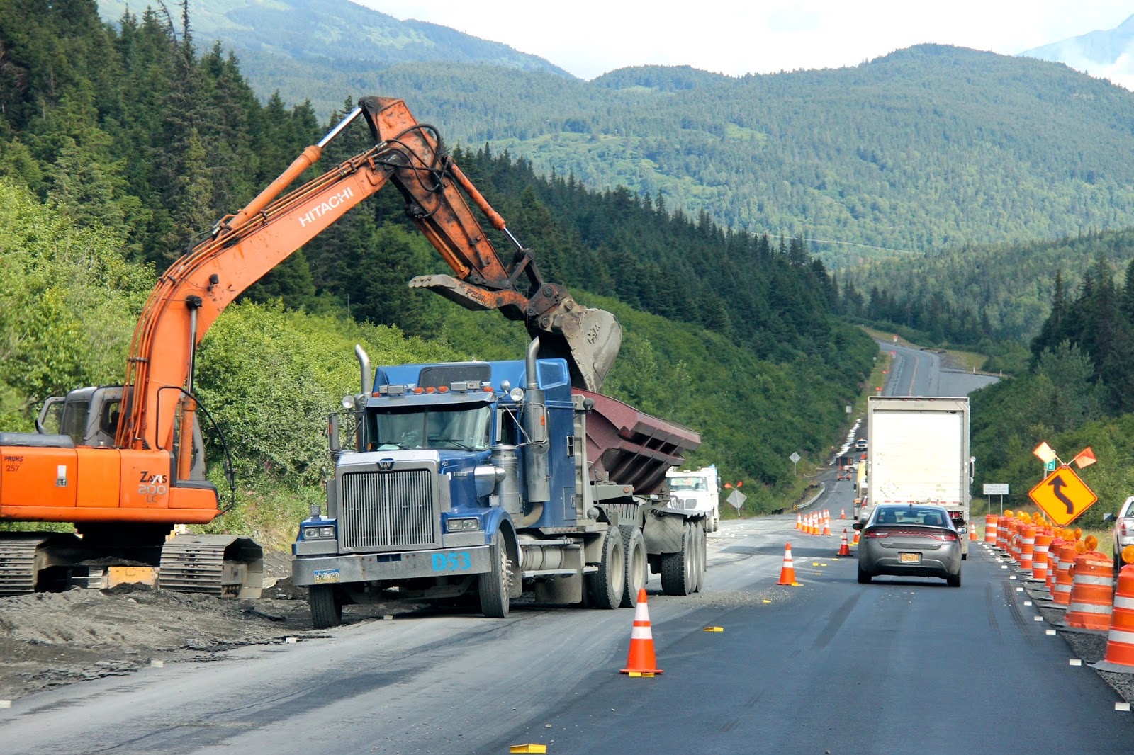
As usual, there is construction along the way.  These dump trucks are unlike any we have seen before.  Instead of emptying from the rear, they dump their load from the side.  This configuration allows them to move larger quantities and control the drop better.
 As we rode along, the recent rains have created waterfalls all along the way.  Some are quite small and gurgle into tiny pools.
Salmon Creek.  This shallow, muddy creek actually does have fish in it.  These guys are trying to snag Silvers.  As we watched, everyone that caught a fish released it.  It looked like from our vantage point that they had snagged them either in the side or tail.  Unless the snag is in the mouth, they have to be released.  Must be frustrating.
 One of the locals leaving with his catch for the day -- a single Silver.  He chatted with us for a few minutes.  He was disappointed with his efforts but that is the way it is sometimes.
Here we are at Earthquake Park.  The park is dedicated to all things that have to do with the 1964 earthquake.  There are trails all over where bikers and walkers can enjoy both the forest and the views.  In the background of this picture is the skyline of Anchorage.
 Ghost Forest.  Part of the aftermath of the earthquake are these ghostly forests.  When the sea water flooded the area it not only killed all the trees but it preserved them as well leaving behind these ghostly forests, stark and beautiful against the green land.
At the wildlife preserve we had a chance to get up close and personal with this fellow.  This moose was relaxing against the fencing.  We reached through and touched his velvet covered antlers.  The texture was soft but soon they would be fully developed and hard and capable of killing another bull moose.  We also touched his hair.  It was wiry and we could feel his body heat radiating.  Amazing.
These two Moose babies were rescued when their mothers were killed.  They are bottle fed several times a day by volunteers.  Now that is a job I would like to have for sure!  They were so cute.
The hide hanging on the wall is from a single Wood Bison.  Conservation work is going on to bring this creature back to numbers so they can be reintroduced into areas where they once roamed free.
The Musk Oxen.  We had seen them before but these were darker in color.  All of these will be released before 2015 ends.
Baby Caribou.  These cute little ones were comical to watch.  The would suddenly run about jumping and leaping for the joy of it.  These were orphaned and are being hand fed.  This heard is scheduled to be released this year too.
 This big Black Beer is one of three blacks that were orphaned.  This guy weighed about 300 pounds.  Blacks encountered in the wild are quite dangerous.  If you happen upon one who attacks you, rangers say fight back.  I would not get a chance to fight, I would faint!
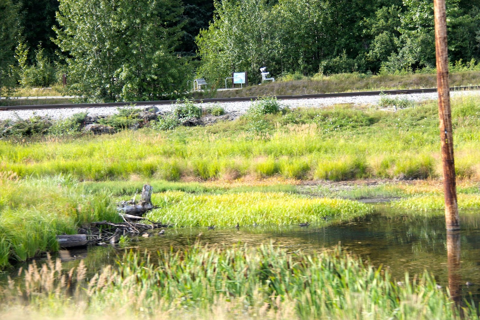
We visited Potters Marsh a wildlife preserve.  This marsh area is home to all sorts of birds and fish plus bears and moose too.
 Finally I got to see Salmon.  The water in the Marsh is fresh.  There is a culvert the leads from Turnagain Arm that allows the Salmon to leave the salt water and go to the fresh to spawn.  This Red Salmon looks pitiful.  It is coming to the end of its life in order to create a new generation.  Mother Nature is not always kind.
This lovely fellow is a Merlin Falcon.  He was about 11 inches tall.  He seemed to be posing for me.  Later, I met some locals who come here very often.  We were all watching an Eagle.  When I turned to go, I pointed out the Merlin to them.  Both were very excited to him as they had not seen him all summer.  Sweet.
This is a yearling Bald Eagle.  We watched him for quite a while.  He was trying to catch a fish.  Once he finally caught one, he had quite a time figuring out how to eat him.  Several times he lost his balance and had to flap his wings to keep from falling over.  Guess all babies have to learn.
One last look at the water and wow, quite a lot of Salmon seemed to be gathering strength to finish their journey.  A great way to end a nice afternoon.

Tuesday, August 11, 2015

Seward, A Bustling Port Town

We arrived in Seward late in the afternoon weary from the long rainy drive.  Our creek side campground was located just outside of town.  After leaving the highway, we crossed over railroad tracks, a one lane bridge and after a short distance the pavement ended.  From there, it was black gravel with potholes big enough to swallow a tire.  I was beginning to think we might regret camping there but when we arrived it was actually pretty nice.  All around were signs warning bear country and with our closeness to water, I wondered if we would see any and I worried about the girls if we did.  Certainly we saw lots of scat all over the property but thankfully we did not encounter any bears face-to-face.

We visited the local Library/Museum.  The museum section was very interesting.  We learned about how the town formed and grew under the guiding hands of many influential people who helped mold the city.  As we have traveled, we have heard many references to the big earthquake that hit Alaska in 1964.  Once daily, the museum runs a film that recounts the events of that day.  It includes pictures and interviews of some of the survivors who still live here in Seward.  We learned about the impact it had on the land, people and economy.

Good Friday, March 27, 1964 was like any other day in the bustling town of Seward.  Seward, one of the few ice-free ports in south central Alaska was an active railroad terminus, fishing port and harbor.  At Seward’s docks, oil-filled storage tanks waited for ships to load and move the oil.  One survivor commented that the afternoon was unusually quite.  There were no animals visible nor any birds singing.  It was a curious calm.  At 5:36 p.m. everything changed as the ground began to shake violently from a 9.3 earthquake.  During the four minutes and thirty-eight seconds of the strongest quake to ever hit North American fissures opened, landslides moved great chunks of earth along the waterfront and harbor into the bay.  Buildings and homes collapsed.  The Standard Oil dock facility ruptured and spewed fuel everywhere.  As the oil tanks overturned, they exploded in a chain reaction.  Residents in areas outside and above the town thought the entire town was engulfed in flames.

A harbor slide called a submarine landslide generated a wall of water 30 feet high that was covered in burning oil that swallowed what remained of the harbor and dock area.  In the process, another forty oil-filled railroad tank cars exploded in chain reaction.  When the first wave subsided, people scrambled their way to higher ground in anticipation of tsunamis.  Twenty-five minutes after the quake, the first tsunami hit with 40-foot waves moving at 100 mph.  As the wave came in, it picked up the burning oil.  As the water extinguished fires it ignited others.   The last of the tsunamis left the town ten hours later leaving 13 people dead and Seward totally devastated.

Okay, okay you are awash with facts but just a couple of more things.  The damage covered the areas from Kodiak in the Aleutian Islands to Anchorage.  Kodiak was raised by 30 feet.  Southeast of Anchorage areas dropped as much as 8 feet.  The Port of Valdez suffered massive underwater landslide resulting in 30 deaths.  And, tsunamis came ashore in British Columbia, Washington, Oregon and California with loss of life there.  The quake was felt as far away as Texas and Florida where Lake Chekika saw water flow rates double from 3 million gallons to 6 million gallons a day.  I had no idea.

The funny thing about earthquakes is the day before we went to the museum, I was walking from the bedroom into the living area when I felt the RV sway.  I thought, what in the world?  Then it shook violently for about two seconds -- enough that I staggered.  As this happened, the news was on the TV and the commentator looked shocked and said, we are having an earthquake!  As it turned out, it was a 6.3 quake.  Not nearly as strong as the quake of ’64 but it scared my mule!

We spent a good bit of time dodging the rain.  We walked around the city and explored the dock area and of course, ate.  The seafood was exceptional.  We spent a good afternoon at the Alaska SeaLife Center.  It is dedicated to all the birds, fish and mammals that have and do inhabit Alaska.  We decided that it would be fun to join the feeding session for the Pacific Giant Octopus.  We went behind the scenes to a classroom setting to learn about these amazing creatures.  We also visited the exhibits to learn about the ones that were on exhibit.  Finally, we went behind the viewing area and touched and fed two different Octopuses.

As we approach August, we are nearing the “rainy” season.  Most of the time, the rain is more a drizzle like the Northwest but there are times it is a downpour.  While they keep photos from being crisp and clear, we have tried not to let the rain keep us from enjoying our trip.  Here are a few to enjoy.


This is a view of the old harbor area or what is left of it.  Below the surface of the water lies the rubble from the original harbor before the '64 earthquake.
I took some pictures at SeaLife of the colorful fish.  They are as colorful as fish you find in warmer waters but make no mistake, that water is cold.  Burr
This handsome fellow is a Puffin.  There was a very nice bird exhibit.  Several times a day, they offer behind-the-scenes encounters with the birds and other creatures.
 This fellow is part to the education outreach.  He goes with teams to schools and other venues as a way to encourage young and old alike to come and visit this special place.
Silver Salmon.  In an area dedicated to Salmon, they had Silvers in all sizes up to adults.  The Silvers are the smallest of the Salmon and locals really want to catch Reds or especially the coveted King Salmon.
Hmmmm, I would hate to meet this fellow in the water!

There are a series of murals all over Homer.  This one is by the famous Hawaiian artist Robert Wyland.  He painted these colorful murals in cities all over America.  I love his work and have several of his prints and even one of his sculpturs.

Homer, Halibut Capital of the World

Homer lies at the end of the Kenai Peninsula on Cook Inlet and Kachemak Bay.  Kachemak Bay is an amazing place where fish and shellfish of all kinds abound.  Halibut is the main focus for fishing but Salmon, Razor Clams, Scallops and Oysters and all sorts of other fish are here as well.  After a beautiful drive, we arrived at our new RV park with a stunning view from atop the bluff overlooking the Bay.  The view is breathtaking.  A short walk down the bluff is the beach with its rocky shoreline.  Winds blew across the water cold and crisp and pretty constant.  Homer has an interesting feature, the Homer Spit.  The spit is a narrow strip of land that juts out between the inlet and the bay.  When we drove out, it reminded me so much of being at the beach of North Carolina’s Outer Banks.  There are all sorts of restaurants and shops and places to go fishing on either side of the road.  The crowds are thick with folks who have come to -- yep, fish for Salmon and Halibut.  Everything is weathered and is witness to the constant winds.  Across the bay, you can see the Kenai Mountains that are glaciated.  There are both state and national parks in the distance.  These are only reached either by boat or float plane.  There are many tours that will take you to the area to view the volcanoes, glaciers and of course, the bears.  It is the time of year when the bears are fishing and preparing for the winter that will come.  We have been lucky enough to see Grizzly Bears fishing in British Columbia so we have decided not to take tour.  That said, I would so love to go over and just see the land.  I am, however, still struggling with my foot and long hours of walking are just not possible.

We enjoyed visiting the historic little village and taking a drive up Skyline Drive for a bird's eye view of the area.  From there we could look down on Homer and see the spit and surrounding area from above.  All along the drive are cabins and homes that cling to the hillside.  I cannot image how wonderful it would be to wake every morning and look out and see this land.  It is wild and untamable.  These waters can be quite dangerous as the winds can whip up high waves without warning.  We are camping next to a couple of veterans who retired from the service and are now living outside of Fairbanks with their families.  Every day they go out in their boat (not a big either) to fish for Halibut.  Sitting outside their RV is a freezer full of Salmon and Halibut, the fruits of their labor.  Gregg told us there is over $1,000 worth of fish in that freezer and more inside their RV.  Folks who live up here really depend on the fish to sustain them through the long, dark months of winter.  I like Salmon and Halibut but not to be the main part of my diet.  These guys are so nice and friendly as is everyone we have met here to date and we enjoyed chatting with them.

We have taken advantage of the bounty of fish too.  Our first afternoon we had lunch at the end of the spit.  I had the most wonderful Halibut ever!  The next night, I had scallops and Jim had Halibut.  I love scallops but these were so sweet and fresh, man I could get used to living here!

We had planned to visit Saldovia, a small village located across the bay yesterday.  Unfortunately, the rains rolled in and the bay was too rough to make the crossing.  Again today, the weather is rainy and cold.  It is unfortunate but not unusual at the beach.  Still, we have enjoyed roaming about seeing the quaint little shops and talking with locals.  I have to remind myself that traveling is more than going from place to place seeing the land and animals.  It is about meeting people and hearing about their lives.  There are many veterans who were stationed here in Alaska that have retired here.  It is great to have a chance to talk with them and hear of their experiences.  Tomorrow we head back up the Kenai to Seward.  The weather is calling for rains.  Well, no matter, we will still enjoy whatever comes our way.


From the bluff, the view of the Bay was amazing.  Across this Bay lies Saldovia a tiny village of 375 souls.  In its hey day, it was a major fishing center.  Now, tourism is what sustains their economy.  Its remoteness is not for everyone but many love that way of life.  The only way in or out is by ferry or water taxi.  If the weather is bad, there is no other way across.
A steep walk down from the bluff lead to the beach.  It is rocky and the sand and rocks are mostly black.  The winds invite birds to ride their currents.  We saw Bald Eagles many times flying high.  Charlotte was so interested in the water but Savannah wanted no part of it.  I cannot blame her, the water was very cold.
This is a sample of what the Spit looks like.  All the building are rustic much like any other beach area.  Small boat docks are behind these buildings.  These docks service the ferries and all sorts of charters.
Of course, restaurants offering the freshest seafood also abound.  Interspersed between buildings are all sorts of places where RVs cluster together.  It is the height of the fishings season and everyone is hoping to catch their limit.  There is an area called the hole that is stocked with Salmon and other fish.  There is one entrance from the open water so the tides bring in other fish.  At any time of the day or night, fishermen line the bank trying their luck.
I took this picture from Skyline Drive.  Below is the Homer Spit reaching out into the Bay.  No matter how many times I see the blues and deep greens, I am always amazed all over again.
From Skyline, the glaciers are seen clearly as they flow to the Bay.  There are so many glaciers all over Alaska.  Their power and majesty dominate the scene wherever no matter where they are located.  I hope climate changes do not rob us of these wonders.
At one place on Skyline we turned down a narrow dirt turnoff.  At the end, the bluff dropped off and gave us a great view of Homer and the Bay.  Someone had put a bench among the berry bushes.  Jim went over and sat down to enjoy the view.  I can imagine whoever placed it there coming here to contemplate and soak up all this beauty.
As we sat on the bench, overhead we heard the now familiar sound of Eagles.  Look closely.  There are two of them riding on the invisible currents of air.  A nice way to end a day.