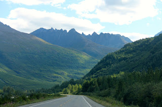
The Glen Highway crosses the Richardson at Glennallen, our intended destination when we headed out from Palmer. Our plans were to stay at Dry Creek State Recreation Campground. To reach the campground, we traveled beyond Glennallen about 8 miles into the forrest. As we pulled into the camp, a little voice in my head said, “uh-oh.” The road in was overgrown and very narrow and looked in need of some TLC for sure. No matter, we continued driving through the loop to find a site large enough for our rig. Everything was overgrown and the sites were quite narrow and worst of all, empty. Well into the camp, we finally passed an occupied site. It was a bit of a shock to me and my little voice said, “no way!” The site was littered with “stuff”, the little camper was quite run down but worst of all, there was a baby play pool set up as a make shift bath. I looked at Jim and he looked at me and we agreed that we were not at all comfortable staying at such a campground. So, we headed out to our plan B site. As it turned out, this one was not suitable either. Our Plan C site was 18 miles back down the Glen and poor Jim was already quite tired. In frustration, he said “oh, to h___ with it, let’s just go on to Valdez. It is only 115 miles. We will be there in 2.5 hours.”
So, after getting fuel, we headed south on the Richardson Highway. Like the Glenn, it is also a scenic highway. For the first fifteen miles or so, the road was good and the views lovely but mostly just forrest. I started focusing on the Milepost (our travel bible) following our route and seeing what lay ahead. When I finally looked up again, what a shock! There before me was a glacier topped mountain rising to the clouds. About that time, Jim hit a frost heave and the rig jarred us into reality.
The reality of the Richardson is it is an awful highway to drive. It is littered with frost heaves and it undulates and worst of all, every expansion joint caused a bump. We were lucky if we could average 35 miles to the hour! We thump, thump, thumped our way while outside the windows the most amazing scenery rolled pass like a movie. We stopped a great deal to take pictures and to give Jim a break from driving. The 2.5 hour drive turned into about four hours!
We arrived in Valdez and immediately knew we were in a special place. Valdez is surrounded by glacier cover mountains. Ah, but I get ahead of myself. Take a trip down the Richardson through my pictures. Oh, be sure to imagine the thump, thump, thump as you do.
The road wound between the green trees and the stark mountains. In this part of Alaska, at 1500 feet trees no longer grow giving the mountains their stark, bare look.
The road wound around and brought us very close to this mountain and its glacier. Some of these glaciers can be reached by foot and you can even walk on the ice.
We crossed many creeks and streams. We stopped at this one (mostly to take the girls out to stretch their legs) and from the bridge the blue, glacial water looked clear and cold. Not sure if there were fish in this one, but they certainly are in many of those streams.
All along the way, waterfalls cascaded down the sides of the mountains. Sometimes, if there were at higher elevations, these waterfalls are frozen. At times, it was hard to tell if they were flowing or frozen.
There are no words.
 This glacier is actually two different glaciers and was massive. They flowed quite near the highway. Hikers could go to the face of these and I wish we could have done it. Fun.
This is Thompson Pass. It is located above 3,000 feet and holds the Alaskan record for the most snow in a year, 83 feet! In 2014, there was an avalanche here that closed the highway for several days. With the Richardson closed, Valdez is cut off by land. Of course, it was cleared in a few days but it still must have caused folks anxiety.
This beautiful waterfall is called the Bridal Veil. The picture does not show the true scale of the falls. It rises about 75 feel above the highway. There is a secondary, smaller fall a short distance away. It was quite spectacular.
This waterfall is dubbed Horses Tail. I suppose one might see that but to me, it was just a pretty fall. By the time we arrived here, both of us were so exhausted that all we could think of was to get out of the truck and get to bed!


No comments:
Post a Comment