
Another day dawned early for us as we had to be ready to go on what we hoped would be an exciting tour — a Jet Boat Journey on the Stikine River. Our gateway city is Wrangell. Wrangell is located on the northwestern tip of the Wrangell Island and is the third oldest community in Alaska, second oldest in Southeast Alaska and the only city in state history to be ruled by four nations and under three flags: indigenous Tlingit, Russia, Great Britain and the US. I knew from other visits to Alaska that Russia was in the history of Alaska but I did not know that Great Britain was. Fear that Great Britain would take possession of Alaska was one of the driving forces for the US to purchase Alaska from Russia.
I want to digress just a bit to tell about the Stikine River and the importance of it to the Alaskian and Canadian indigenous peoples. The Stikine River flows from an area known as the Sacred Headwaters in British Columbia into Southeast Alaska. The Tlingit, Haida and Tsimshian people have occupied this region for more than 10,000 years. The Stikine supports five different species of salmon, as well as moose, geese, deer and multiple other game that are integral to the diet of the entire community. In 2019, the Stikine River was named among America’s most endangered rivers, citing the grave threat that current and proposed mining projects pose to the river’s salmon, culture and economy. American Rivers and its partners called on the International Joint Commission of the U.S. and Canada to stop the mining projects from devastating the river, its salmon and communities.
We all know about the Exxon Valdez and the Deep Water Horizon oil spills. But I would bet few if any of us know about what is happening to rivers in Alaska, the Stikine being one of them. The Stikine is threatened by the pollution from an operational mine at the headwaters—the Red Chris Mine, with others proposed nearby. These mines are extracting minerals, including silver, gold, molybdenum and copper. The Red Chris Mine is owned by the same company, Imperial Metals, responsible for a massive dam failure in 2014 at its Mount Polley site that polluted lakes and rivers with 24 million cubic meters of toxic waste. Mines are required to keep their tailings (toxic ore waste potentially containing cyanide, arsenic, and/or mercury) immersed in water in perpetuity. The earthen dams holding the tailings at the Stikine mines are engineered in the same way as the failed dam at Mount Polley. During our boat ride up the river, our Captain spoke about the failed dam and the damage it did to the rivers. Salmon are particularly sensitive to ore waste especially copper. A tiny amount of copper in the water causes the Salmon to lose their ability to know how to find their fresh water stream in order to spawn. Interestingly enough, the company has yet to acknowledge their responsibility for the damage to the ecosystem, nor have they worked to find solutions to keeping it from happening once again. Sadly, it is just another example of how the drive for money trumps saving our world.
 Okay, off my soapbox. We exited the Victory and headed to the meeting area where we would board a jet boat. Our Captain was a tall, white haired man with a warm smile and fir handshake. We could immediately tell he was a local because he wore sandals! Burrr! Our jet boat is a relatively flat bottomed affair and could carry about 20 people including the Captain and deck hand. The Captain began to tell us all about this river system. The Stikine River, Shtax’héen in Tlingit, or Bitter River, is known for its tremendous size and complex braided waters. It is the fastest free-flowing navigable river in North America. He told us what the volume of water was flowing through the river but I cannot remember what it was. The river has lots of sandbars and channels that move and change daily. He shared that he must check daily and adjust the path he will follow accordingly. Wow, talk about a challenge. The water at the dock is salt but eventually it will become fresh, that is the fresh water will float on top of the salt (if I understood him correctly).

 We headed out. Immediately we could see the winding route he would follow as I could see the gps clearly. All along the way, fallen trees and other debris dotted the shallow waters. Captain told us that since the land shifts and the water flows so strongly, trees and other plant life fall and then lay there providing resting places for birds and others. Almost immediately, he spotted a Bald Eagle sitting atop a fallen tree branch. The Captain throttled back to a stop so we could see and photograph this majestic creature. Further down the river, we passed a sandbar where Harbor Seals were congregated. There were lots of them relaxing in and out of the water. After more photos, we headed out once again.
 Since the land is controlled by the federal agencies, only a few cabins are seen on the banks of the river. The water is controlled by Alaska so we saw floating cabins. These houseboats are built and then floated down river to a place were the bottom is mostly flat. The house is then anchored and can be used as a weekend or vacation or hunting base. Since the river is tidal, there can be as much as 11 feet difference between high and low tides. The river level can also rise quite a bit due to storm or other increases in water volume. These fluctuations in water level can sometimes cause the house boat to sit on the bottom, thus the need for it to be flat.

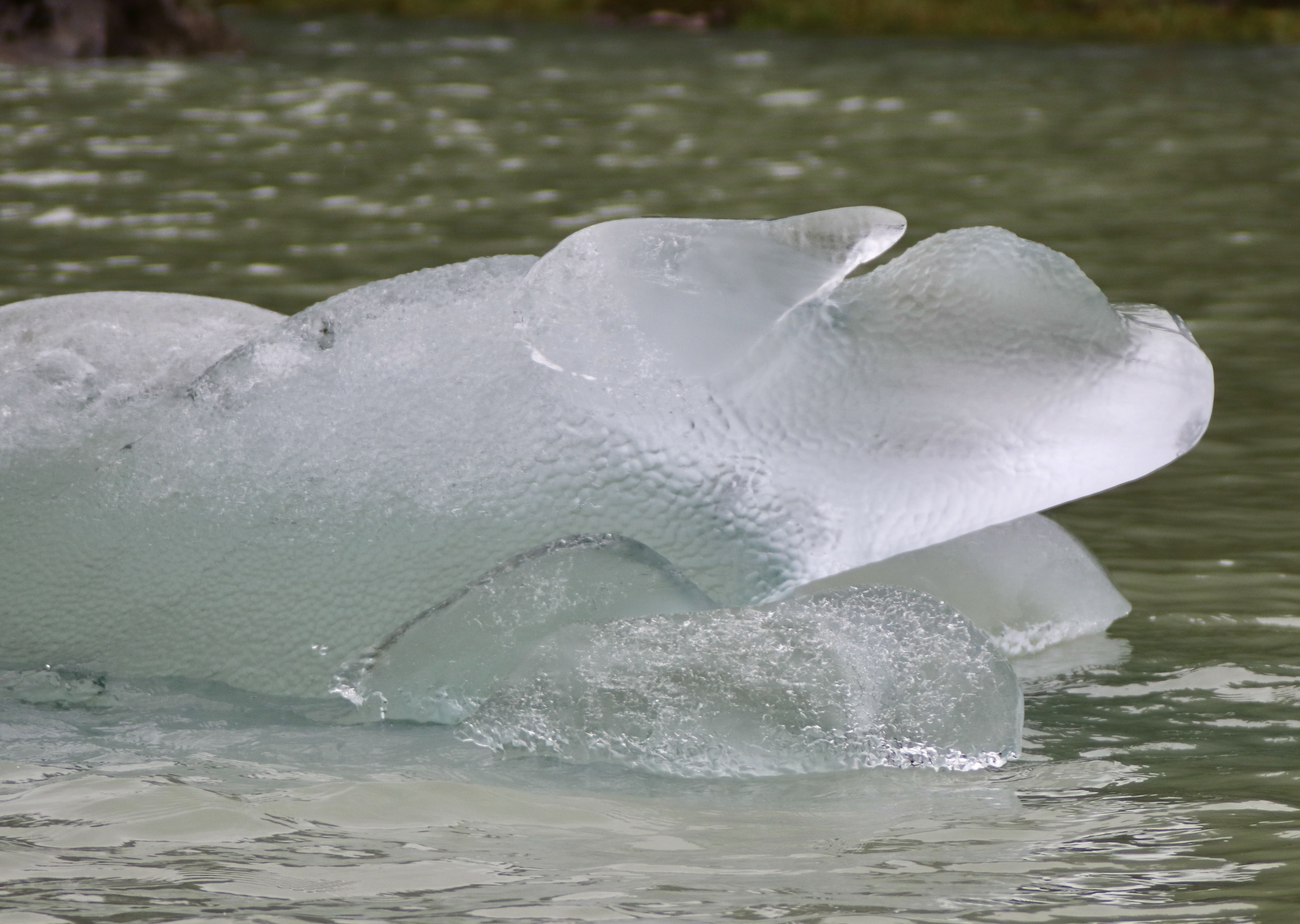
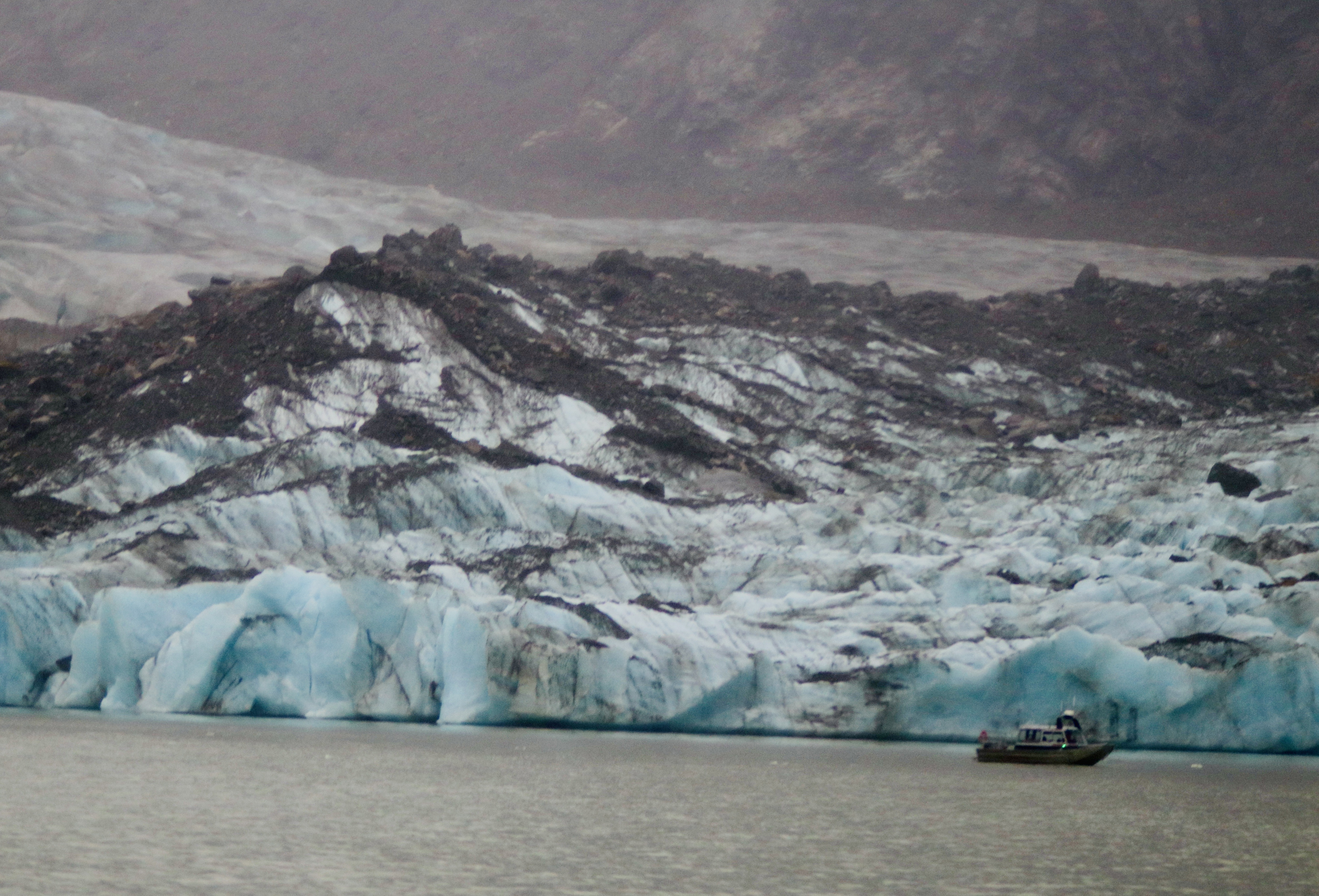
 The cold air brushed against our faces as we glided across the water, through sloughs and past rushing waterfalls. It continued to rain and the temperatures began to drop signaling we were entering the lake. Gradually, ice chunks started to drift past us. They got larger and larger. The Captain explained that these chunks had calved and are then trapped in the lake. Finally, the ancient ice formation of Shakes Glacier came into view. No matter how often I see a glacier, it is still an awesome site. The deep blue typical of the glacier is just amazing. This glacier does calve, but not as much as the other glaciers we had seen. We spent quite a bit of time at the glacier photographing it and just enjoying being in front of a lake glacier.


 The ice was not the only focus for our wonder. The rocks on the surrounding rock walls were so amazing and beautiful. These formations were formed when liquid rock mixed with existing rocks. Sort of like adding nuts to cake batter, it all becomes a cake but the nuts maintain their individual form and color. There were swirls of shades of brown with white and beige and other colors mixed in. The Captain commented he would love to have a slab to make a kitchen counter! So would I, I thought. Amazing and bold and beautiful
While at the face, the deck hand broke out beer and wine and smoked Sockeye Salmon along with cheese and crackers for us to snack on. Oh my goodness, the Salmon was so delicious! It was not served sliced thinly but was in thick chunks of goodness. She shared that she had extra onboard for sale too. Of course we purchased a couple of boxes to take home, Yummy.
 After returning back to the dock where the Victory was anchored, we then joined an Island Heritage Discovery Tour. The bus took us through the small village of Wrangell down to their city dock area. Wrangell has a huge contraption that allows them to pull large vessels onto the dry dock where they can enjoy repair and cleaning. It is the only one in these waters and is a good source of income for the town.
Our first stop was at the Chief Shakes Tribal House. This amazing wooden plank house was carved by traditional methods with traditional tools. These highly decorated houses are usually home to large families. In the middle, there is a large fireplace. Smaller cooking fires would dot the areas further away from the middle. Your station in the family would determine how close to the fire you would sleep. The chief would be the closest, the shaman would be next and the lowest or slaves would be the furthest. Good for the chief but not so good for the slaves! We enjoyed hearing several of the Tlingit stories about the Raven and others, all part of their rich heritage.


 Next, we headed to the Petroglyph Beach to experience the mysteries of ancient petroglyphs — rock carvings. No one exactly knows who or why these petroglyphs were carved. We walked on the rocky beach searching for rocks that held these carvings. It was strange, we could look at them and they seemed barely visible. Once they were photographed however, they were clear and sharp. In the Tlingit art custom, only certain shapes are used. It is said that one can start at any point in the art and travel all over it without ever crossing an intersection. One of the petroglyphs had a round, spiral shape that is not customary in Tlingit art. So, who carved this one? Very interesting.

Our tour ended with the Wrangell Museum. It traced the history of the area from ancient times up to the present. The area is rich in history about mining, fishing and hunting. It also traces their experiences through WWI and WWII. I was surprised to see the exhibit on printing and they had an old printing press. Now that is a blast from the past for us. They also had exhibits including Wyatt Earp, who served as a temporary Marshall for 10 days while he and his wife, Josie, travelled north to the Klondike. Explorer and naturalist John Muir wrote of many adventures in and around Wrangell. Soapy Smith, famed outlaw, used the town to hide-out when things got too hot in Skagway. Lots of fun history.
We returned to the Ocean Victory around five, tired but glad we had the time to see this place. Tomorrow would be another expedition day so it will be busy. Wonder what we will have good for dinner?
 The First Nations (Canadian native people) people explored these picturesque waters in hand-carved cedar canoes. As we journey through the narrow maze of channels, passages and reaches, we hope we too will see wildlife and magical scenery. Perhaps we might even see a Spirit Bear. What is that? The Spirit bear is a Kermode bear that is a subspecies of the American Black Bear and lives in the Central and North Coast regions of British Columbia, Canada. While most Kermode bears are black, between 100 and 500 fully white individuals exist. The white genetic variant is known as spirit bear, and is most common on three islands in British Columbia (Gribbell, Princess Royal, and Roderick), where they make up 10–20% of the Kermode population. Spirit bears hold a prominent place in the oral traditions of the indigenous Peoples of the area.
 The scenery has been relaxing and beautiful. The surrounding hills and mountains are covered with green of all shades. The trees are thick, old growth forest. Along the way, waterfalls cascade down and flow into the water. It is both peaceful and relaxing.


